Mapping Your Climb
Kilimanjaro Map
Welcome to your Kilimanjaro climb! As you prepare, it's important to discuss about an important tool that's often overlooked - Kilimanjaro Map.
According to us, carrying Kilimanjaro Maps is super important. These maps have all the details about different paths and where you can camp. This helps you pick the best route that fits what you like and how good you are at climbing.
In the read below, we've put together all the maps on each Kilimanjaro Climbing Routes, showing you where the camps are and what to expect. Also, we talk about using static and dynamic maps and their importance.
So, grab your map and let's start planning your Mount Kilimanjaro Climbing Tours. We are sure, that with the right map in your hand, every step towards the top of Mount Kilimanjaro is going to be exciting and safe.
Kilimanjaro Location and Facts
Learn facts about Tanzania's towering volcano, rich in nature and adventure!
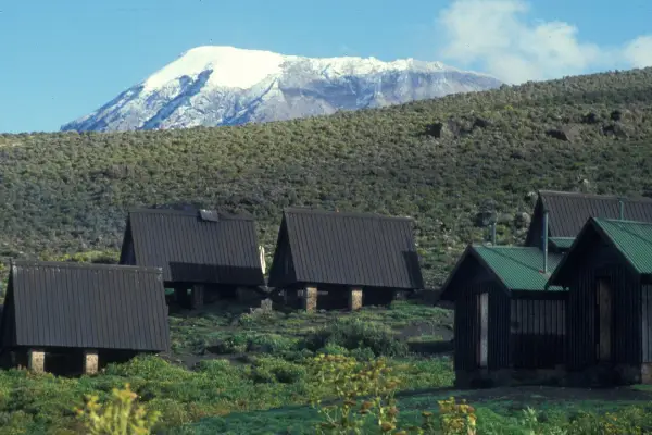
Mount Kilimanjaro is a giant mountain located in Tanzania, close to the equator. It's famous for being the highest mountain in Africa and is made up of three volcanic cones—Kibo, Mawenzi, and Shira. Kibo is the highest peak, where most climbers aim to reach the summit at Uhuru Peak. Some Key Facts about Kilimanjaro are outlined below:
 Location: 205 miles from the equator in Tanzania, near the Kenya border.
 Region: Located in the Kilimanjaro province of Tanzania.
 Mountain Range: Part of the Eastern Rift mountains.
 Airports Nearby: Close to Kilimanjaro International Airport, with access from Nairobi or Mombasa.
 Volcano Type: Dormant, with the last activity over 200,000 years ago.
 Highest Point: Uhuru Peak on Kibo, at 5,895 meters above sea level.
 Climatic Zones: Passes through five ecological zones from forest to arctic.
 First Successful Climb: By Ludwig Purtscheller and Hans Meyer in October 1889.
 Geographical Coordinates: 3.0674° S, 37.3556° E.
 Nature of Peak: Volcanic Mountain with three cones.
Mount Kilimanjaro Maps & It's Peaks
Know about Kilimanjaro's 3 peaks and 7 routes with our detailed, informative maps.
In this section, we will talk about 2 Mount Kilimanjaro Maps.
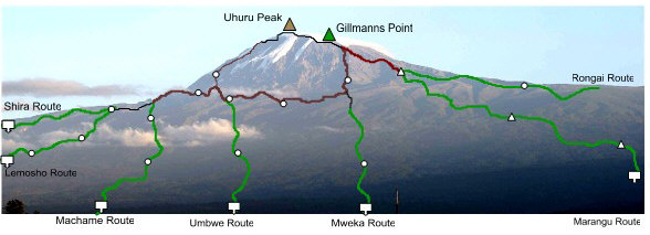
One is a Kilimanjaro Map that shows all the 5 routes to reach the summit. There is a total of 7 Kilimanjaro Climbing Routes to reach the summit. But, at Jerry Tanzania Tours, we recommend going for Kilimanjaro Treks via 5 routes namely, Machame, Rongai, Marangu, Lemosho and Northern circuit route. A detailed map showing all the 5 routes is represented below.
The next is a map that shows clear information on Mount Kilimanjaro and its 3 peaks. Mount Kilimanjaro is made up of three volcanic cones:
 Kibo, which is the tallest at 19,340 feet. The highest point here is called Uhuru Peak, also known as Kaiser Spitze.
 Mawenzi, which stands at 16,893 feet might remind you of a dramatic mountain from a movie because of its rugged appearance.
 Shira, the oldest of the three, isn't as distinct as a cone because it collapsed long ago. Now, the area is known as the Shira Plateau, beautifully shaped by lava flows from Kibo.
Knowing about these peaks helps climbers choose the right route on the Kilimanjaro Climbing Routes Map. Each route offers different views and challenges as it passes near or around these volcanic cones. Understanding the geography of the peaks can enhance your climbing experience.
Using Maps to Find Your Ideal Route
Use detailed maps to navigate and select your perfect Kilimanjaro route.
Picking the right path for your Kilimanjaro Climb is very important for a fun and safe adventure. Maps can help you see the differences between the paths, so you can choose the best one for you. At Jerry Tanzania Tours, we recommend five special Kilimanjaro Climbing Routes, each with its good points.
 Machame Route gives great views and is good for getting used to the high altitude.
 Lemosho Route, starts quiet and slow, which helps you adjust to the height.
 Rongai Route comes from the north and is less crowded.
 Northern Circuit takes the longest time to reach the summit while giving you a full experience of Kilimanjaro.
 Marangu Route has huts to stay in and a straightforward path, making it easier for some climbers.
These routes are chosen because they give you the best chance of having a great climb. They have nice views, enough time to get used to the high altitude, and a good chance of making it to the top.
Even though the Marangu Route can get busy, it's still a good option if you like a simpler climb. The other four routes are perfect if you enjoy camping and quieter paths. Our Kilimanjaro Maps show you what each route is like, so you can pick the right one for your adventure.
Let's dig into the details of each Kilimanjaro Climbing Routes Map one by one.
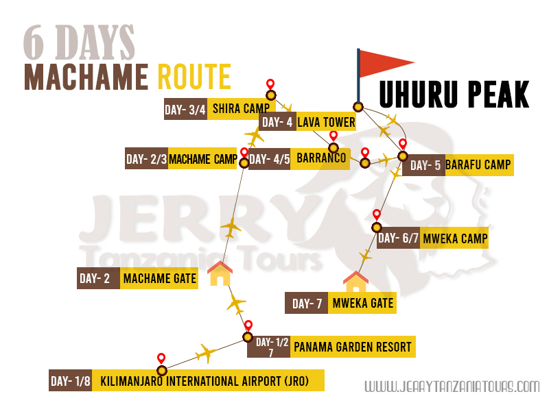
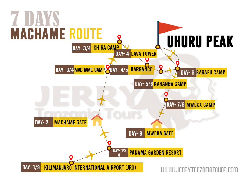
Machame Route
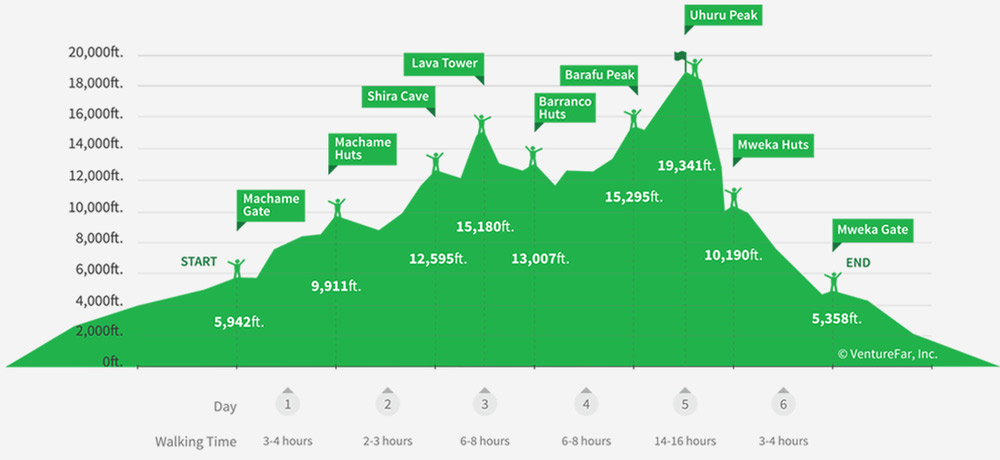
The Machame Route is known for its scenic beauty and effective acclimatization opportunities, making it a popular choice among climbers.
The Machame Route Map details this path, showing key elevation points and the varied terrains you'll traverse, from lush forests to the rocky Barranco Wall. This route is ideal for both beginners and experienced climbers due to its gradual ascent and high success rates.
|
Camps along the Machame Route
|
|
Camp Name
|
Elevation
|
|
Machame Camp
|
2,835 meters (9,300 feet)
|
|
Shira Camp
|
3,750 meters (12,300 feet)
|
|
Barranco Camp
|
3,960 meters (13,000 feet)
|
|
Karanga Camp
|
4,035 meters (13,250 feet)
|
|
Barafu Camp
|
4,640 meters (15,200 feet)
|
|
Mweka Camp
|
3,100 meters (10,170 feet)
|
The Machame Route Kilimanjaro Map not only guides you through each segment of the climb but also prepares you for the changing environments as you ascend.
The gradual increase in elevation at each camp helps climbers acclimatize properly, increasing the chances of a successful summit.
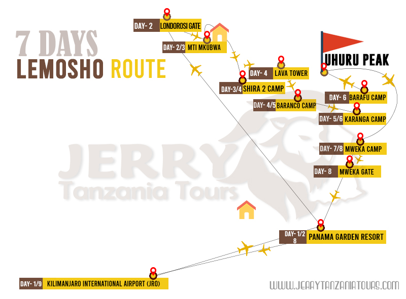
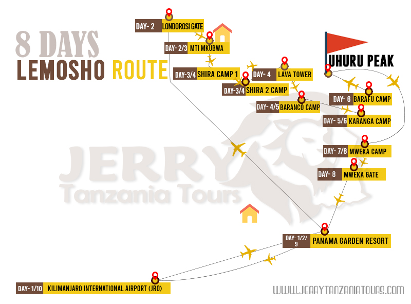
Lemosho Route
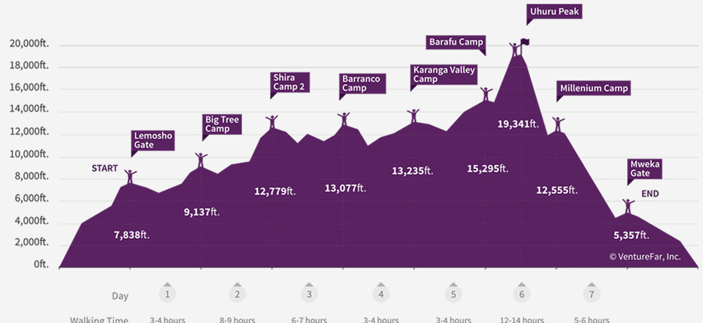
The Lemosho Route is popular for its stunning landscapes and effective acclimatization schedule.
The Lemosho Route Map illustrates this pathway in detail, highlighting the key elevation points and the diverse terrains you'll encounter, from the remote rainforests at the start, across the expansive Shira Plateau, to the challenging ascent towards the Lava Tower.
This route suits both novice and seasoned climbers, thanks to its gentle ascent and excellent acclimatization opportunities.
|
Camps along the Lemosho Route
|
|
Camp Name
|
Elevation
|
|
Big Tree Camp
|
2,820 meters (9,250 feet)
|
|
Shira Camp 1
|
3,500 meters (11,500 feet)
|
|
Shira Camp 2
|
3,850 meters (12,600 feet)
|
|
Barranco Camp
|
3,960 meters (13,000 feet)
|
|
Karanga Camp
|
4,035 meters (13,250 feet)
|
|
Barafu Camp
|
4,640 meters (15,200 feet)
|
|
Mweka Camp
|
3,100 meters (10,170 feet)
|
The Lemosho Route Map navigates you through each stage of the climb and prepares you for the varied environments you will traverse. The progressive increase in elevation at each campsite facilitates proper acclimatization, significantly enhancing the likelihood of reaching the summit successfully
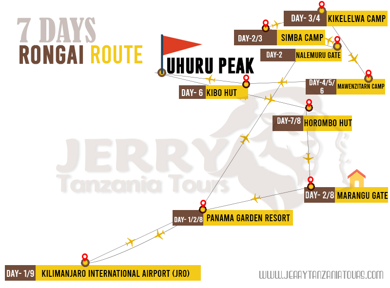
Rongai Route
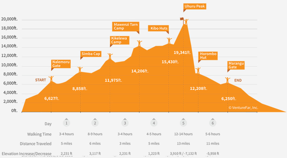
The Rongai Route is unique as it starts from the north near the Kenyan border. It offers climbers a different perspective and experience compared to other routes on the mountain.
This northern approach provides more shelter, making it an excellent choice during the rainy seasons, which are from mid-March to early June and November to early December.
|
Camps along the Rongai Route
|
|
Camp Name
|
Elevation
|
|
Simba Camp
|
2,830 meters (9,300 feet)
|
|
Second Cave Camp
|
3,450 meters (11,320 feet)
|
|
Kikelewa Camp
|
3,600 meters (11,811 feet)
|
|
Mawenzi Tarn Camp
|
4,315 meters (14,160 feet)
|
|
Kibo Hut
|
4,720 meters (15,485 feet)
|
|
Horombo Hut
|
3,720 meters (12,205 feet)
|
This route also allows trekkers to experience remote wilderness areas before it converges with the Marangu Route at Kibo Camp.
Though it may not boast the varied scenery of the Machame or Lemosho routes, its tranquillity and gradual ascent make it highly favourable.
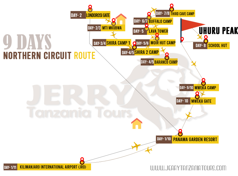
Northern Circuit Route
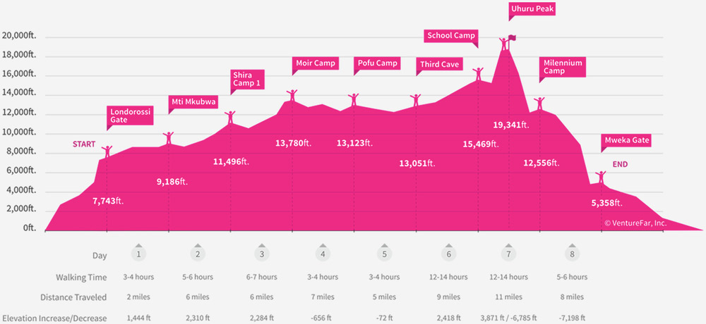
The Northern Circuit Route is perfect for climbers who need more time to adjust to high altitudes. It's the longest route on Kilimanjaro, which helps climbers acclimatize better and enjoy high success rates.
Starting at the same point as the Lemosho Route, it veers north, exploring quieter, less-travelled paths around the northern side of the mountain before reaching Lava Tower and then ascending to Uhuru Peak via Gilman's Point.
This route is similar in difficulty to the Machame and Lemosho routes but provides a distinct experience due to its extended length and northern approach.
|
Camps along the Northern Circuit Route
|
|
Camp Name
|
Elevation
|
|
Mti Mkubwa Camp
|
2,820 meters (9,250 feet)
|
|
Shira Camp 1
|
3,610 meters (11,850 feet)
|
|
Shira Camp 2
|
3,850 meters (12,600 feet)
|
|
Moir Hut
|
4,200 meters (13,780 feet)
|
|
Buffalo Camp
|
4,020 meters (13,190 feet)
|
|
Third Cave Camp
|
3,870 meters (12,700 feet)
|
|
School Hut
|
4,800 meters (15,750 feet)
|
|
Crater Camp
|
5,730 meters (optional) (18,800 feet)
|
|
Mweka Camp
|
3,100 meters (10,170 feet)
|
By using a detailed Kilimanjaro Map, climbers can plan and visualize their journey along the Northern Circuit, preparing for each segment and campsite.
This preparation helps maximize the chances of a successful and enjoyable climb, making every step on this less-travelled route a memorable adventure.
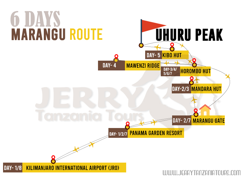
Marangu Route
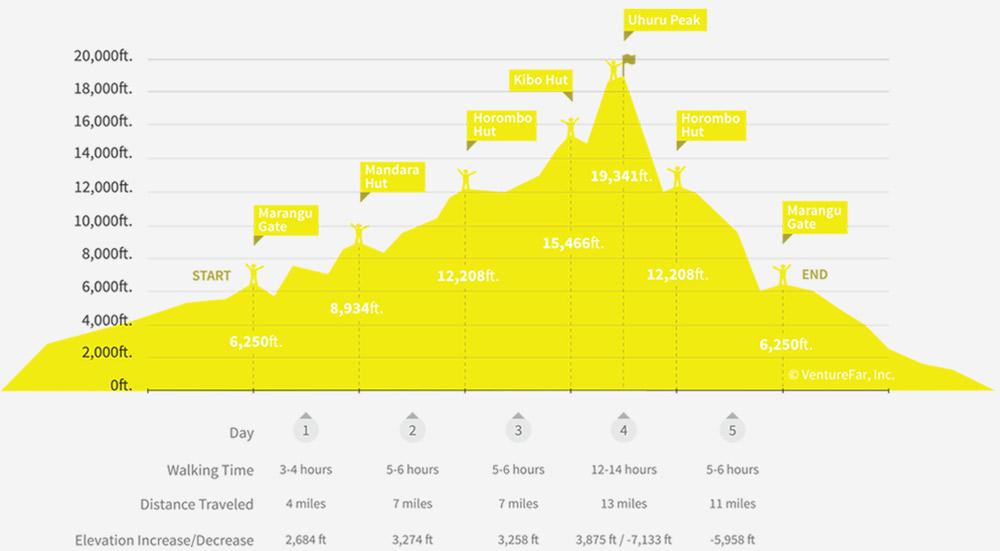
The Marangu Route is also known as the "Coca-Cola" route. It is special because you can sleep in huts instead of tents. This path starts from the southeast and is easier to walk because it has a gentle slope and a straight path. It is very popular for those who want a simpler climb.
This route is quicker but you have to be careful with getting used to the high altitude because it's faster. Even though it's easy, you need to prepare well.
|
Huts along the Marangu Route
|
|
Huts Name
|
Elevation
|
|
Mandara Hut
|
2,700 meters (8,858 feet)
|
|
Horombo Hut
|
3,720 meters (12,205 feet)
|
|
Kibo Hut
|
4,720 meters (15,485 feet)
|
The Marangu Route is not as pretty as other Kilimanjaro Climbing Routes because you see the same views going up and coming down.
But it's still chosen a lot because of the huts and the easier path. A map can help you see what to expect on this route and plan how to handle the quick climb to high places.
Static Vs Dynamic Kilimanjaro Maps
Plan your Kilimanjaro Climb with detailed static and real-time dynamic maps.
There are two main types of Kilimanjaro Maps you might use: static and dynamic maps. Each type of map serves a different purpose and can be very helpful depending on your needs.
Static Maps
Static maps are essential for climbers because they provide a clear overview of the mountain's geography, showing exactly where you'll be heading as you ascend and descend.
 Show all Kilimanjaro Climbing Routes and their starting points.
 Include locations of campsites, peaks, safari routes, caves, and huts.
 Great for seeing the path you will take up and down the mountain.
Dynamic Maps
Dynamic Kilimanjaro Maps are more interactive and can give you real-time updates about the area surrounding Kilimanjaro, including how to get there and what other attractions are nearby.
 Update with information like nearby towns and road networks.
 Useful for planning travel to and from the mountain.
 Show driving times and distances which is helpful for safari planning.
Both static and dynamic maps are valuable tools for anyone Climbing Kilimanjaro.
Static maps help you visualize your route and prepare for the trek, while dynamic maps assist with logistics and travel arrangements before and after your climb.
Using both can ensure a well-planned and successful adventure on Mount Kilimanjaro.
Achieve Summit Success with the Right Kilimanjaro Maps and Guidance!
Although climbing Kilimanjaro is achievable for many, nearly 50% of climbers face challenges, often due to altitude sickness. At Jerry Tanzania Tours, we focus on using the right Kilimanjaro Maps and proper acclimatization to help you be well-prepared. With detailed maps and experienced guidance, we help 95% of our climbers successfully reach the summit.
Wish to reach the top of Africa? Browse our Kilimanjaro Climbing Packages, and let our team help you navigate the right path with confidence and ease. Contact us today to plan your adventure!
KILIMANJARO MAPS FAQ's
Get the Right Answers for Your Kilimanjaro Map Adventure
While having a Mt Kilimanjaro Map is helpful, it's not recommended to climb without a guide. Guided climbs ensure your safety, especially when it comes to handling altitude and navigating difficult terrains. A guide's experience is very vital for a successful summit.
Yes, you can download digital versions of the Kilimanjaro Routes Map. These maps can be accessed on your smartphone or GPS devices. However, it's always smart to carry a physical map as a backup in case of battery issues or weak signals.
A Kilimanjaro Climbing Routes Map provides details on all major routes, campsites, and significant landmarks. It shows the starting points, elevation changes, and important points like Lava Tower and Barranco Wall, helping you visualize your path to the summit.
The coordinates of Mount Kilimanjaro are 3.0674° S, 37.3556° E. These coordinates are typically included on the Mount Kilimanjaro Routes Map and help in locating the exact position of Kilimanjaro on various navigation systems, ensuring you stay on track.
Yes, carrying a physical Map of Mt Kilimanjaro is highly recommended. While guides are there to lead the way, a map offers extra security and can be useful in case you want to track your progress or double-check your route.
Absolutely. Kilimanjaro Maps show the elevations of camps along the routes, helping you plan your acclimatization strategy. By knowing the heights of each campsite, climbers can manage their ascent carefully, reducing the risks of altitude sickness.

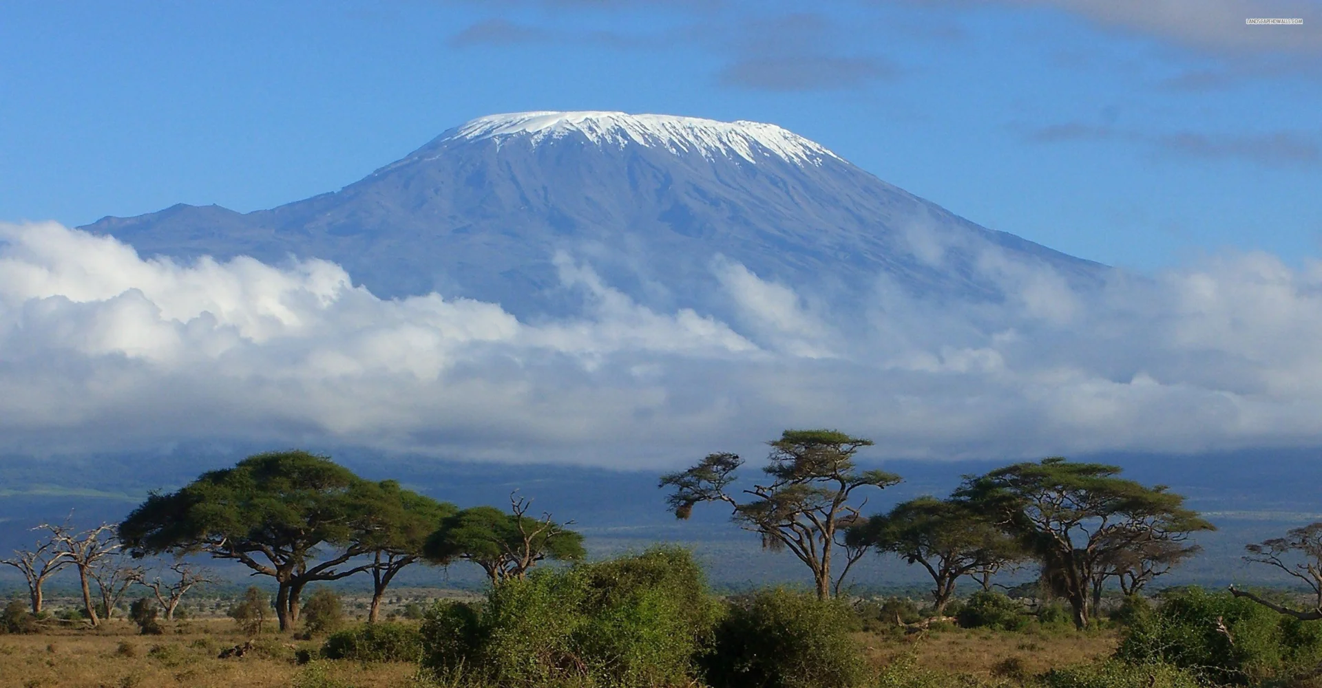

 Location: 205 miles from the equator in Tanzania, near the Kenya border.



 Whatsapp
 Chat Online



 Subscribe On Youtube
 1 Year ago


